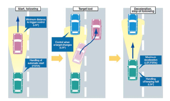
How to select Liar Sensors Technologies is critical on the ADAS application. Based on recent trends, highly automated driving may soon become available, though safety concerns remain. Self-driving cars rely on three key components: environment sensing, behavior planning, and motion execution. Perception is particularly challenging due to the dynamic nature of traffic and varying external conditions. LiDAR technology, integral to ADAS, provides key advantages in addressing these challenges, leading to ongoing research and development for safer, autonomous driving.

Artificial Vision:
is widely used in robotics, surveillance, and industry due to its cost-effectiveness and ability to analyze spatial, dynamic, and semantic information. Cameras on the market offer varying resolutions and frame rates but face challenges in automated driving, especially under difficult lighting conditions. Different light and visibility conditions (such as glare, shadows, and darkness) affect the reliability of artificial vision. Far infrared (FIR) and near-infrared (NIR) cameras help improve visibility in low-light situations. High Dynamic Range (HDR) technology addresses the challenge of extreme lighting differences, and new automotive-grade sensors with HDR and NIR capabilities have been developed to enhance visibility in such conditions.
3D vision technologies extend traditional 2D camera systems by providing depth information, crucial for automotive and other applications. Key methods include:
- Stereo Vision: Utilizes two cameras to calculate depth from visual disparities, producing dense depth maps but struggling with low-texture surfaces.
- Structured Light: Involves projecting a known infrared pattern on a scene and capturing distortions with a camera, generating depth maps. It’s less reliant on surface texture but limited by range and light interference.
- Time-of-Flight: Measures the round-trip time of infrared light emitted and reflected from a surface to calculate distance, offering high refresh rates but limited by range and ambient light conditions.
Here is a list of advantages and disadvantages for the three types of 3D vision technologies:
1. Stereo Vision
Advantages:
- Produces dense depth maps by calculating the displacement of features between two cameras.
- Well-suited for detailed scene depth estimation in various environments.
- Less dependent on external lighting (compared to structured light or time-of-flight sensors).
Disadvantages:
- Low-texture surfaces (e.g., solid colors) make it difficult to match visual features between frames, leading to errors in depth calculation.
- Requires precise calibration between the two cameras.
- Challenging in situations where depth features are sparse or homogeneous.
2. Structured Light
Advantages:
- Less affected by surface texture compared to stereo vision, making it effective for capturing depth in low-texture environments.
- Lower computational cost due to the structured light pattern simplifying depth calculation.
- Provides more reliable depth information in controlled environments.
Disadvantages:
- Limited operating range (typically under 20 meters) due to emitter power and ambient light intensity.
- Requires precise calibration for accurate depth mapping.
- Performance is sensitive to reflections and ambient light interference, which can distort the light pattern.
3. Time-of-Flight (ToF)
Advantages:
- Provides high refresh rates (50+ Hz), making it suitable for real-time applications.
- Capable of creating accurate depth maps even in low-light or varying light conditions.
- More scalable in terms of depth range compared to structured light.
Disadvantages:
- Short operating range (10–20 meters) in automotive applications, limiting its use in large outdoor environments.
- Ambient light (e.g., sunlight) can interfere with the infrared light used by ToF sensors.
- Indirect ToF methods or avalanche photodiodes can extend range but add complexity and cost.
Emerging Vision Technologies: Event-based vision sensors trigger asynchronously and independently in response to changes in light intensity, producing streams of events rather than traditional frame-by-frame images. This technology allows for a dynamic range of 120 dB, enabling high-speed applications, especially in low-light conditions. The sensors operate at sub-microsecond speeds, tracking up to 1000 FPS, even in indoor lighting, and are highly efficient for applications like visual odometry and SLAM, reducing CPU workload. Additionally, research is ongoing on sensors that capture light polarization to enhance performance in adverse meteorological conditions and extract unique information (e.g., materials, composition, and water in roads).
Radar Technology:
Radar uses high-frequency electromagnetic waves to measure object distance based on the round-trip time of the wave bouncing back to the sensor. Frequency-modulated continuous wave (FMCW) radar is common in automotive applications and uses beamforming to direct transmitted waves. Radar can determine both distance and relative velocity using the Doppler effect. It operates well in adverse conditions such as rain, fog, and snow, with ranges up to 250m.
Advantages:
- Unaffected by weather and lighting conditions.
- Effective in low-visibility situations like fog or dust.
- Can measure both distance and speed of objects.
Challenges:
- Sensitivity to Reflectivity: Radar can be confused by materials with different reflective properties, leading to false alarms or missed detections.
- Resolution and Accuracy: Although radar can measure distance and speed precisely, its horizontal and angular resolution limits its ability to separate nearby objects, especially at longer distances.
Emerging Radar Technologies:
New research focuses on high-resolution radar, improving target detection, and object separation. Examples include the use of 90 GHz radars for detailed mapping of vehicles and their surroundings, as well as advanced materials and antennas for synthetic aperture radar (SAR). This allows for more efficient and accurate mapping of the environment, with improvements in atmospheric absorption and reflectivity detection.
LiDAR Technology:
LiDAR (Light Detection and Ranging) uses NIR (Near-Infrared) lasers to measure distances by calculating the round-trip time of laser pulses. This technology allows for highly accurate distance measurements (up to 200 meters), often utilizing rotating mirrors for 360-degree horizontal coverage. Commercial systems can have multiple vertical layers, generating a 3D point cloud representing the environment.
Advantages:
- Provides high accuracy in creating digital 3D maps.
- Effective in outdoor conditions, even in direct sunlight.
Drawbacks:
- Low vertical resolution in low-cost models (typically fewer than 16 layers), affecting performance at longer distances.
- Sparse data: Commercial models have gaps in coverage, which can lead to undetected objects.
- Struggles with dark or specular objects: LiDAR is less effective at detecting objects that absorb or scatter light poorly (e.g., black cars).
- Affected by weather conditions like rain and fog, which scatter the laser beam and reduce range and accuracy.
Emerging LiDAR Technologies:
- FMCW LiDAR (Frequency-Modulated Continuous Wave): Measures object velocity using the Doppler effect, useful for tracking moving objects and behavior prediction.
- Solid-State LiDAR: Includes technologies like oscillating micromirrors and optical phased arrays (OPA). These offer fast and precise scanning with better field of view (FoV), enabling dynamic adjustments to beam density and improved long-range performance.
OPA technology also allows for random scanning patterns across the entire field of view, providing high-resolution object tracking, even at long distances.
Differences between Radar and LiDAR:
|
Feature |
Radar |
LiDAR |
|
Technology |
Uses electromagnetic waves to measure distance and speed |
Uses laser pulses to measure distance |
|
Range |
Effective up to 250m, even in poor weather conditions |
Effective up to 200m, but affected by weather (rain, fog) |
|
Performance in Conditions |
Works well in poor visibility (rain, fog, dust, and darkness) |
Struggles in poor weather, performance declines in rain or fog |
|
Accuracy |
Moderate spatial resolution, can detect speed using Doppler effect |
Higher spatial resolution, generates detailed 3D maps |
|
Cost |
Typically lower cost compared to LiDAR |
More expensive due to higher precision and complex setup |
|
Object Detection |
Handles detection of both fast-moving and stationary objects well |
Better at detecting static objects, but may struggle with dark or specular surfaces |
|
Penetration |
Can penetrate through certain materials like fog or dust |
Cannot penetrate through materials like fog or rain |
Advantages of LiDAR:
- High Accuracy and Precision:
- LiDAR provides highly accurate measurements of distance and spatial relationships, allowing for precise 3D mapping of the environment. It can detect objects and surfaces with millimeter accuracy, making it ideal for applications like autonomous driving and terrain mapping.
- High Spatial Resolution:
- LiDAR systems generate detailed 3D point clouds, offering high spatial resolution. This level of detail enables precise modeling of the environment, including small objects, contours, and surface variations.
- Effective for Complex Environments:
- LiDAR is highly effective in detecting and mapping complex environments, such as urban landscapes or dense forests. It can capture fine details, including the shape and position of multiple objects in a single scan.
- Works Well in Day and Night Conditions:
- LiDAR uses laser pulses that are independent of ambient light, meaning it can function equally well in daylight or darkness, unlike cameras which require adequate lighting conditions.
- Rapid Data Acquisition:
- LiDAR systems can capture data at high speeds, often scanning their environment in real-time, which is important for dynamic environments like those encountered in autonomous driving or drone navigation.
- 3D Mapping Capabilities:
- LiDAR excels at creating 3D maps of the surrounding environment. This is critical for applications such as autonomous vehicles, robotics, and geospatial analysis, where understanding the depth and contours of an area is crucial.
- Penetration of Vegetation:
- LiDAR can penetrate through vegetation (e.g., tree canopies) using its dense point cloud data to provide accurate ground elevation maps, making it ideal for topographic mapping and forestry applications.
- Ability to Detect Small Objects:
- LiDAR’s high resolution allows it to detect small and fine objects (such as traffic cones or wires) that other sensors like radar might miss, making it crucial for safety in autonomous systems.
- Minimal Interference:
- LiDAR operates using narrow beams of laser light, which are less susceptible to interference from other LiDAR systems or environmental noise, making it reliable for consistent performance in multi-LiDAR settings.
- 360-Degree Scanning:
- LiDAR systems, especially those with rotating mirrors or multiple emitters, can achieve 360-degree horizontal scanning, providing a complete view of the surroundings.
These advantages make LiDAR an essential tool for industries like autonomous driving, robotics, geospatial analysis, and environmental monitoring where high accuracy and real-time 3D mapping are crucial.
Disadvantages of LiDAR:
- Weather Sensitivity:
- LiDAR’s performance deteriorates in adverse weather conditions like rain, fog, or snow because the laser beam scatters, leading to reduced accuracy and range.
- Low Vertical Resolution:
- Low-cost LiDAR systems typically have fewer vertical layers (less than 16), resulting in poor vertical resolution. At long distances, this can lead to large vertical gaps, making it difficult to detect smaller objects.
- Sparse Metric:
- LiDAR may have sparse data points depending on the model, which can create gaps in detection. This makes it challenging to detect smaller or thinner objects (like rods or wires) and reduces its ability to create dense, continuous 3D maps.
- Poor Detection of Dark or Specular Objects:
- Dark-colored or reflective objects (like black cars or shiny surfaces) can be difficult for LiDAR to detect because they absorb or reflect very little of the laser light, reducing the return signal strength.
- Cost:
- High-resolution LiDAR systems, especially those with advanced features like multiple layers or solid-state technology, tend to be expensive, making them cost-prohibitive for widespread use in certain applications.
- Power Consumption:
- LiDAR systems, especially when using multiple layers or rotating mirrors for 360-degree coverage, can have relatively high power consumption, which may not be ideal for energy-constrained applications.
Despite these disadvantages, LiDAR remains highly effective in providing detailed, high-resolution 3D environmental mapping, making it crucial for the selection of Lidar Technologies for applications like autonomous driving.


