LiDAR (Light Detection and Ranging) is a versatile sensing technology capable of measuring distance, angle, intensity, velocity, and composition of objects and environments. Depending on system architecture and detection method, LiDAR can operate as 1D, 2D, or 3D, and can be extended with advanced techniques such as Doppler, synthetic aperture, and spectroscopic LiDAR.
Range Measurement Fundamentals
LiDAR determines range by measuring the time-of-flight (ToF) of a laser pulse traveling to a target and back. The achievable range resolution is governed by the system bandwidth:
ΔR = c/2B
where:
- c is the speed of light
- B is the system bandwidth
Higher bandwidth enables finer range resolution, making short-pulse and frequency-modulated systems particularly effective.
Angular Resolution and Sampling
Angular information is obtained by sampling the field of view (FOV) using a detector array or by scanning a narrow beam. The achievable angular resolution is limited by:
- The diffraction limit of the transmit/receive aperture, and
- The angular subtense of each detector pixel
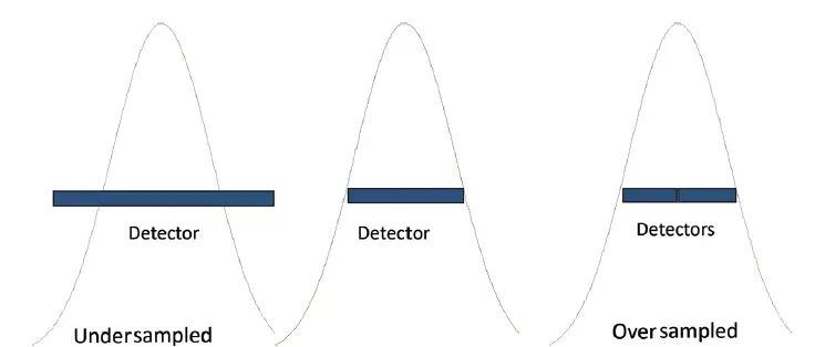
Proper sampling of the point spread function (PSF) is critical:
- Undersampling → loss of spatial information
- Critical sampling → optimal resolution
- Oversampling → increased data volume without resolution gain
These regimes determine image quality and system efficiency.
1D, 2D, and 3D LiDAR Systems
1D LiDAR (Range Only)
- Measures distance along a single beam
- Minimal angular information
- Common in speed detection and simple ranging
2D LiDAR (Range + Angle)
- Measures range with azimuth and/or elevation
- Reduces clutter and false detections
- Produces images similar to electro-optical (EO) sensors, but encoded in range
3D LiDAR (Range + Angle + Intensity)
- Captures full spatial geometry
- Often includes grayscale intensity (reflectance) information
- Widely used in mapping and object reconstruction
The number of grayscale intensity levels is defined by:
Ng = 2N
where N is the number of grayscale bits. Intensity data typically represents:
- Range information
- Reflectance contrast, based on returned photon counts per pixel
Beyond Geometry: Advanced LiDAR Measurements
Velocity and Vibration (Doppler LiDAR)
Coherent LiDAR systems measure phase and frequency shifts to extract velocity via the Doppler effect. This enables:
- Wind field mapping
- Vibration analysis
- Vehicle speed measurement
Doppler LiDAR is used in airport operations, meteorology, and military surveillance.
Synthetic Aperture LiDAR (SAL) and MIMO
Synthetic Aperture LiDAR (SAL) combines signals from multiple transmit and/or receive apertures and applies Fourier processing to synthesize a larger effective aperture. This improves spatial resolution beyond what a single physical aperture can achieve.
Multiple-input, multiple-output (MIMO) LiDAR—adapted from radar concepts—further increases imaging capacity, angular diversity, and robustness.
Spectroscopic and Chemical LiDAR Techniques
Differential Absorption LiDAR (DIAL)
DIAL uses two wavelengths:
- One absorbed by a specific gas
- One not absorbed
By comparing return signals, gas concentration can be measured. This technique is used to detect ozone, CO₂, methane, and water vapor, including programs such as ARPA-E MONITOR.
Raman LiDAR
Raman LiDAR relies on inelastic scattering, where energy transfer to gas molecules shifts the returned wavelength. This enables identification and quantification of atmospheric gases.
Laser-Induced Fluorescence (LIF) LiDAR
LIF LiDAR excites real electronic transitions in target materials, enabling detection of biological or chemical substances.
Laser-Induced Breakdown Spectroscopy (LIBS) LiDAR
LIBS vaporizes material and analyzes emitted spectra to determine composition. This technique is famously used by NASA Curiosity rover to identify rock types on Mars.
LiDAR Applications Across Industries
- Autonomous Vehicles: LiDAR is a core sensor for driverless cars. Early adoption was demonstrated in the DARPA Grand Challenge, and it remains essential in modern ADAS and AV systems.
- Unmanned Aerial Vehicles (UAVs): Used for obstacle avoidance, navigation, and mapping—including logistics UAVs operated by Amazon.
- Consumer Electronics & Gaming: Depth-sensing systems such as Microsoft Kinect introduced LiDAR-like technologies to mass markets.
- Forestry & Environmental Monitoring: Measures forest canopy structure, biomass, and floodplain mapping.
- Infrastructure & Urban Planning: Used for transportation route design, cellular network planning, oil and gas exploration, and regulatory compliance scans of building interiors.
- Defense & Security: Supports reconnaissance, target identification, and military planning with high-accuracy 3D terrain data.
- Scientific & Cultural Heritage: Enables crime scene reconstruction, archaeological mapping, and precision 3D digitization for simulation and 3D printing.
Summary
LiDAR technology spans far beyond simple range measurement. From 1D distance sensing to high-resolution 3D imaging, velocity detection, and chemical identification, LiDAR systems support a wide range of applications across transportation, aerospace, defense, environmental monitoring, and consumer technology.
Its precision, flexibility, and ability to capture rich multidimensional data make LiDAR an indispensable tool for building accurate digital representations of the physical world.